

The best site plan viewer for iPad is the one that keeps the current plan page attached to the field question you need to answer. Open the local PDF, confirm you are on the right sheet, establish its scale before measuring, record the observation where it happened, and export a review someone else can understand. You do not need GIS, a project-management system, or full CAD editing just to complete that sequence.
That distinction matters because "site plan viewer" can mean several different things. A civil designer may need a design tool. A project manager may need tasks, drawings, and team coordination. A field reviewer with an issued PDF usually needs a narrower workflow: see the right site context, verify one condition, and leave a traceable note behind.
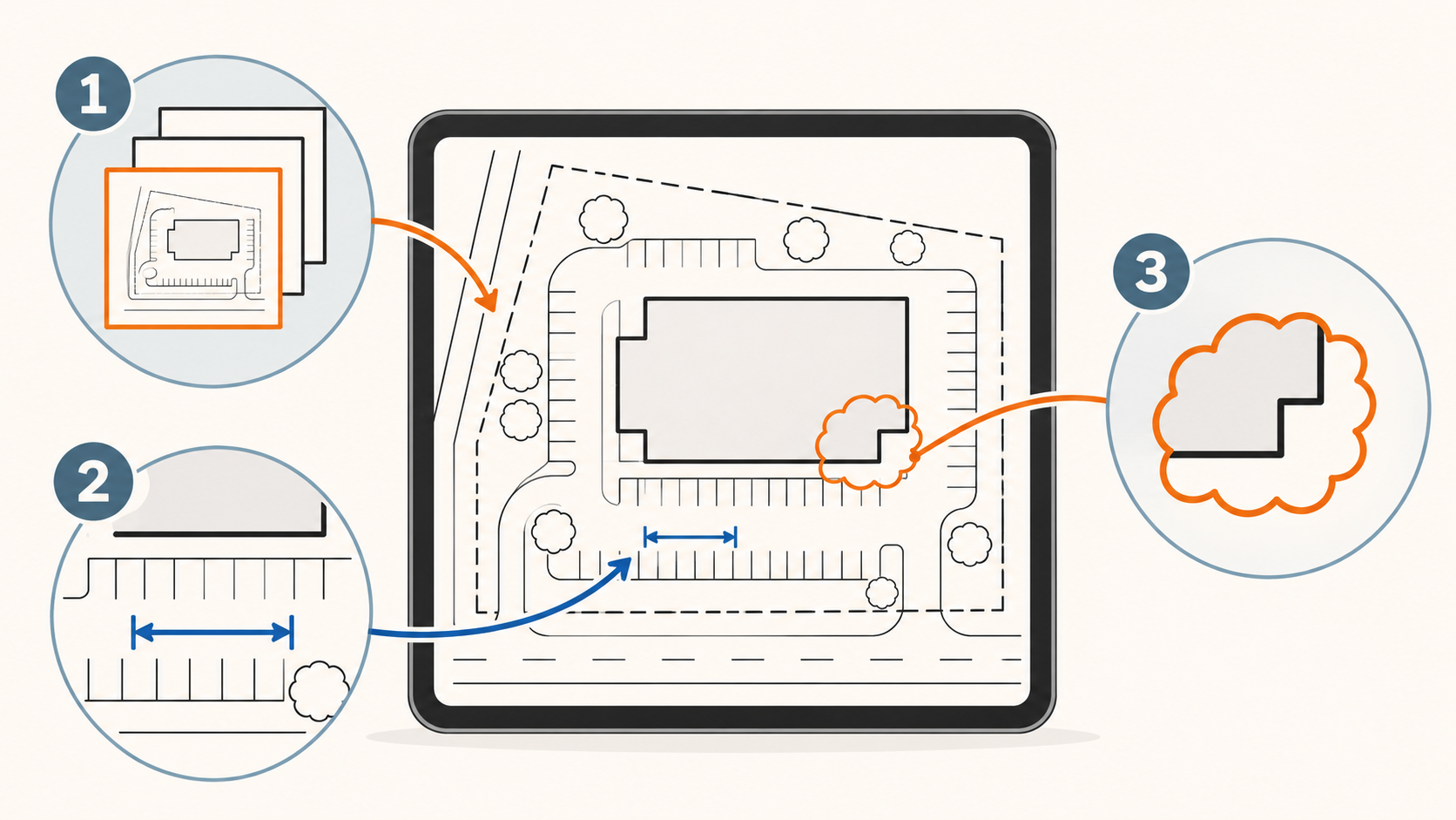
What an iPad site plan viewer should do
A site plan can include parking, grading, utilities, access, landscape, setbacks, building footprints, and notes at very different scales. It is easy to make a confident-looking mistake when the reviewer is on the wrong page or has assumed that a detail uses the same scale as the overall site sheet.
For an issued PDF, look for a review workflow that can do these jobs:
| Review need | What to test on an iPad | Why it matters |
|---|---|---|
| Local access | Open the PDF from the path your team already uses | The review should not start with a conversion or a new account |
| Sheet context | Move through the complete plan set and identify the active page | A correct observation on the wrong sheet is still a bad handoff |
| Scale confidence | Calibrate or confirm the active page from a known dimension | A displayed PDF is not automatically trustworthy for measurement |
| Field evidence | Place a note, markup, or photo at the relevant plan location | The next reviewer can see what the observation refers to |
| Handoff | Export a reviewed plan or notes report | The decision should survive after the iPad leaves the site |
PlanInspect is built for this review path. It opens local multipage PDFs on iPad, keeps each page available as a reviewable sheet, supports per-page scale calibration, measurements, notes, photos, pen, highlighter, and text markups, then exports the reviewed output. See the full PDF plan viewer overview if you are comparing the underlying workflow rather than only this site-plan use case.
Start from the issued file, not a recreated plan
The first choice is simple: begin with the current PDF your team received. On iPad, the Files app lets you choose an app with Open With for a file stored locally or through an available Files location. That gives the reviewer a direct route from the team’s existing file handoff to the plan review.
Before discussing a condition, check the file identity with the person who issued it. Then open the set and identify the page that contains the site area, detail, or utility run in question. An overall civil site sheet and an enlarged entrance detail may show the same place at different scales. Treat the selected page as an explicit part of the observation, not as background scenery.
For a detailed walkthrough of keeping the whole PDF set together, read how to review a multipage construction plan set on iPad. If your bottleneck is simply finding and opening the PDF in Files, the local PDF opening guide is the direct companion.
Confirm the page scale before you measure anything
Zooming into a PDF makes linework larger. It does not establish a real-world distance. Site-plan measurements become useful only after the active page has a valid scale.
When the page contains a reliable labeled dimension, use it as a known reference. In PlanInspect, place two points at the endpoints, enter the real length, then verify a second known distance somewhere else on the same page. If the second check does not agree, stop there. You may have the wrong page, an unreliable reference, a distorted scan, or a plan that is no longer the current issue.
The scale is page-specific. Do not assume that an overall plan, a planting detail, and a curb-ramp detail share a measurement setting merely because they arrived in the same PDF. The detailed guide to PDF plan scale calibration on iPad explains the two-point method and its checks. For a measurement-specific workflow, continue to how to measure a PDF plan on iPad.
Vector PDFs may let a viewer assist with point placement on supported paths. Scanned pages do not expose those paths, so measurements and markups need deliberate manual placement. Either way, a scan can still be reviewed after a trustworthy calibration; it just should not be treated like vector geometry. This is one reason the plan’s source quality belongs in the review conversation.

Turn one site question into a plan-tied observation
Most useful field reviews answer a bounded question, not the whole plan at once. For example:
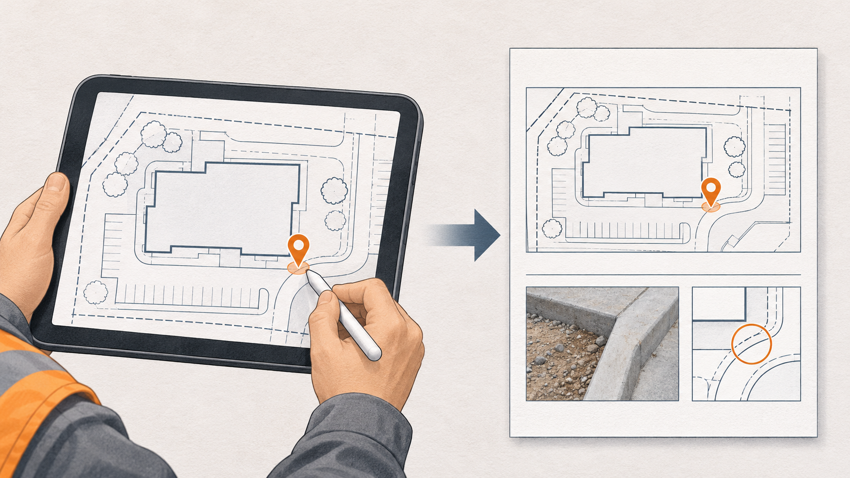
- Is the curb return located where this issued page indicates?
- Does the visible clearance match the dimension that the team is relying on?
- Which location on the plan needs clarification before the next trade begins work?
- Is the reviewer looking at the overall site sheet or a detail that changes the interpretation?
Work through the answer in this order:
- Keep enough of the page visible to identify the surrounding site context.
- Zoom to the exact condition, then make the scale check if a measurement is relevant.
- Add a short note describing what was seen and why it matters.
- Add a photo only when it clarifies the condition; the plan location and image should support each other.
- Mark the observation visibly enough that a recipient can find it without rebuilding the field conversation.
Apple’s own PDF tools can be perfectly adequate for a quick highlight, shape, or text note; Apple documents PDF annotation in Preview on iPad. A dedicated plan-review workflow is more useful when the annotation needs to remain connected to the active site-plan page, a checked scale, and a review-ready export.
Use site notes when a photo-backed observation will make the condition less ambiguous. For a broader operational check before sharing a PDF review, the iPad PDF plan review checklist is the hub to keep nearby.
Choose the tool category that matches the job
It helps to be honest about what the site-plan workflow does and does not need. GIS, construction-management, and mobile CAD tools each solve real problems. They are simply not interchangeable.
| If your main job is… | The useful category | What this article covers |
|---|---|---|
| Locate assets geographically, work with map layers, or inspect coordinates | GIS or mapping system | No — this is not a GIS guide |
| Assign tasks, manage teams, or coordinate a project record | Construction-management platform | No — this is not a task-management workflow |
| Create or alter source CAD geometry | Full CAD authoring software | No — PlanInspect is not a CAD editor |
| Review one local issued site-plan PDF, check its page scale, mark an observation, and export it | Plan-review viewer | Yes |
For comparison, DWG FastView’s mobile product promotes broad viewing, editing, annotation, account/cloud access, and multi-device use. Autodesk’s mobile-viewing guidance also routes readers through its mobile app or web viewer. Those can be suitable when their wider CAD or account-based workflows are the requirement.
Use PlanInspect when the real decision is narrower and plan-first: open the local PDF without a required account, retain the current sheet and its scale, make a location-aware observation, then export the handoff. It is not the right promise for OCR, text search, password-protected PDFs, PDF optional-content layers, automatic revision comparison, construction takeoff, spreadsheets, live collaboration, or full CAD editing.
Export while the field context is still clear
The point of the note is not to leave a colored mark behind. It is to give the next person enough context to act without guessing.
Before you share a review, check three things:
- The page shown is clearly identifiable as the page you reviewed.
- The location and wording make sense without a phone call from the site.
- Any measurement is described as a checked review point, not a quantity takeoff or a guaranteed design instruction.
PlanInspect can export the source PDF page with review overlays, so the recipient gets the original plan context plus the comments you made. The export guide for PDF plan markups and reports explains how to choose a concise reviewed plan or report for the next step.
FAQ
Can I use an iPad to review a site plan PDF without a GIS app?
Yes. If the job is to read the issued local plan, verify a bounded condition, and record a location-aware observation, a PDF plan-review workflow is enough. Use GIS only when your work requires geographic layers, coordinate-based location, or a map-centric data model.
Is a site plan PDF automatically to scale on iPad?
No. A displayed PDF page needs its scale confirmed or calibrated from a reliable known dimension before a distance or area is used in a review. Verify a second known dimension on the same page before relying on the result.
Can I annotate a scanned site plan?
Yes. A scan can be viewed, calibrated from a trustworthy known dimension, measured with deliberate manual point placement, and annotated. It does not provide the vector paths required for snapping assistance.
Can PlanInspect edit the source PDF or CAD drawing?
No. PlanInspect is for reviewing local DWG drawings and PDF plans with measurements, notes, markups, and export. It does not offer full CAD authoring or source-geometry editing.
Keep the site question with the plan
A useful iPad site-plan workflow does not need to become a larger software category. Start with the local issued PDF, name the active sheet, establish the page scale when measurement matters, capture the observation at the right location, and export a result that survives the trip back to the office. That is the practical job a plan-review viewer should make easier.